
The Ben Lomond Peak Trail ride is a true classic. It has a good mix of terrain and outstanding views as you ride through the trees to the narrow ridges over smooth winding trails to gnarly rocky switchbacks. The numerous exposed narrow sections of the trail really get your attention in spots.
This trail is difficult, but not so much until you reach the base of the final accent to Ben Lomond Peak. The trail begins in the North Ogden Divide above North Ogden Utah. From the Parking area cross the road to the North and begin to climb. The first part is generally smooth but there are a few switchbacks that will require some attention and skill. Pay particular attention in this first section to hikers, horse riders, and mountain bikers. We went on a Saturday and it was busy, you will find less crowds on other days. Be especially courteous and share the trail, there are many blind corners and slow riding may be necessary to avoid collisions. It is a privilege to have this trail open and doing so should allow continued use. The traffic generally clears up a bit the further you ride and the trail opens up a bit as well. As the trail opens up you'll be able to see Ben Lomond Peak in the distance. There is a trail sign at the base and this is where the going will begin to get more difficult. The switchbacks up the peak are steep, sharp, and loose although entirely rideable with skill and technique. After reaching the top of the switchbacks, there is a very short hiking trail to reach the peak to the left(West). The trail continues to the North towards Willard Peak and ends up on the dirt road in Willard Basin near a spring. This section is not as difficult as the climb up Ben Lomond, but there are some tricky sections and it is very exposed in many sections. Pay attention and don't slide off the trail. Occasionally you will see mountain goats in this area as well. We were out of water, so it was nice to be able to fill up at the spring before heading back.
- Distance Traveled: 22 miles
- Difficulty: Difficult
- Best Time To Ride: Summer
- Time To Complete: 3 to 4 Hours
- Type: Single Track, out and back
- Elevation: Min 6,147. Max 9,530
- Location: North Odgen Canyon Road (see map)
click for Directions to the trail head from your location. See map below for route information.
Key GPS Points
- Parking: 41.320204,-111.899274
- Trail Head: 41.320667,-111.898951
- Ben Lomond Peak: 41.363095,-111.960879
- Meet Willard Peak Road, End Trail: 41.391109,-111.978161
- Spring: 41.391503,-111.976351
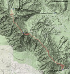 |
| Printable Trail Map |


No comments:
Post a Comment