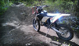
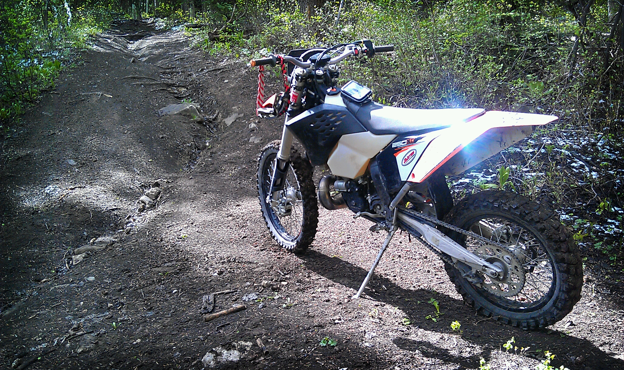
The Ephraim Canyon Single Track Trail near Ephraim Utah is a conglomerate of trails that make a fun loop for dirt bikes. These trails have been poplular with local mountain bikers who normally ride the trails from top to bottom. There are many sections that are not feasible for mtb's to climb. More and more dirt bikers have begun to use and maintain the trail, and for good reason, it's fun!
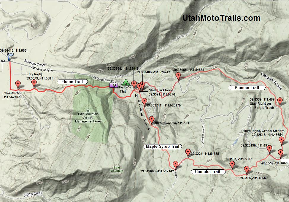
The loop can be traveled in either direction, but the direction I prefer is counter clockwise. To reach the trail travel up Ephraim Canyon Road from the 4 way stop for 1.34 miles. The paved road on the right leads to the trail but you must first go through a neighborhood and past a small farm. As you pass the farm the road turns 90 degrees to the left. After it turns the trail will be straight ahead to the East. This first trail is "The Flume" and you will travel it both directions unless you prefer to return down the canyon road. There are 2 options at the beginning of the trail that take you to the same spot. Go along the fence line then stay right at the fork in the single track and go towards the mountain. After going trough a small wash and over a rock obstacle the trail climbs and is easy to follow. In another mile or so the trail becomes exposed and then crosses a rickety attention getting bridge. Taylor's flat can be seen down below at this point(a possible staging/camping area). Continue along this same elevation on an easy part of the trail until you come to a dirt road where you'll see a pipe to the left. Turn right on the road then stay right on the high road where shortly you'll see another trail to the right. This is the start of the backbone trail. You will come to a road again where you'll have to ride up the road for another short distance before picking up the trail again to the right. This trail is rocky and fun. Shortly you will end this trail and intersect the dirt road where you will see a yurt tent structure on the right. The trail continues straight across the road at this point and becomes the Maple Syrup Trail. This trail travels for another mile or so until you will tee with willow creek road. Turn left on willow creek road and travel for 1500 feet to the Camelot Trail Head which begins on the right before you come to a pond. The Camelot Trail will go for another mile or so before it also tees with and atv/jeep trail. Turn Right and continue up the atv trail where it will shortly tee with another jeep trail. Take a right at this trail and continue for about a half mile to the main canyon road. Turn right and travel up the main canyon road for about 1000 feet to a dirt road and campground on the left. After going through the campground(about 1000 feet), there is a trail to the right that goes through a small stream. This is where the Pioneer Trail starts. It will at one point intersect with an atv trail where you will need to cross to continue on the single track, but it's pretty easy to follow. The trail will come to an exposed section with a few wooden bridges. After this exposed section the trail ends and there looks to be 2 small dirt roads. Take the dirt road to the left where you will see the canyon road in under 500 feet. Turn right onto the canyon road. From here you may return down the main canyon if you don't with to go back down the Flume Trail. To return down the Flume Trail(recommended), look for the A-Frame cabin on the right. The canyon road switches back at a 90 around this cabin. Instead of turning on the canyon road take the jeep trail straight ahead. It will turn along side the canyon road, but go up a little in elevation. In about 1,000 feet you will see the pipe where you were before when the loop started. Turn left at the pipe onto the trail and begin down the Flume Trail to return.
- Distance Traveled: 14 Miles
- Difficulty: Difficult
- Best Time To Ride: Summer
- Time To Complete: 1 to 2 Hours
- Type: Mostly Single Track
- Elevation: Min 5,752. Max 8,635
- Location: East of Ephraim (see map). Click for Directions to the trail head from your location, see the map below for route information
Key GPS Points
- Trail Head From Canyon Road: 39.34415,-111.565
- Start Flume Trail: 39.337675,-111.562707
- Begin Loop, Turn Right: 39.33769, -111.52919
- Backbone Trail Head: 39.337093,-111.527613
- Stay Right Continue on Backbone Trail: 39.333741, -111.526175
- Trail Crosses Road Near Yurt, Begin Maple Syrup: 39.32968,-111.524
- Tee With Willow Creek Road, Turn Left: 39.319666,-111.517142
- Left Off Willow Creek, Start Camelot Trail: 39.322388,-111.513551
- Tee With ATV Trail, Turn Right: 39.319695, -111.50073
- Tee, Turn Left: 39.318591,-111.496578
- Tee Main Canyon Road, Turn Right: 39.323195,-111.490003
- Turn Left Through Campground: 39.3223,-111.4868
- Pioneer Trail Head: 39.32515, -111.48654
- Tee Main Canyon Road, Turn Right: 39.33955, -111.51638
- Veer Left Near A-Frame Cabin: 39.337486,-111.526742
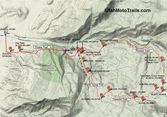 |
| Printable Trail Map |
 |
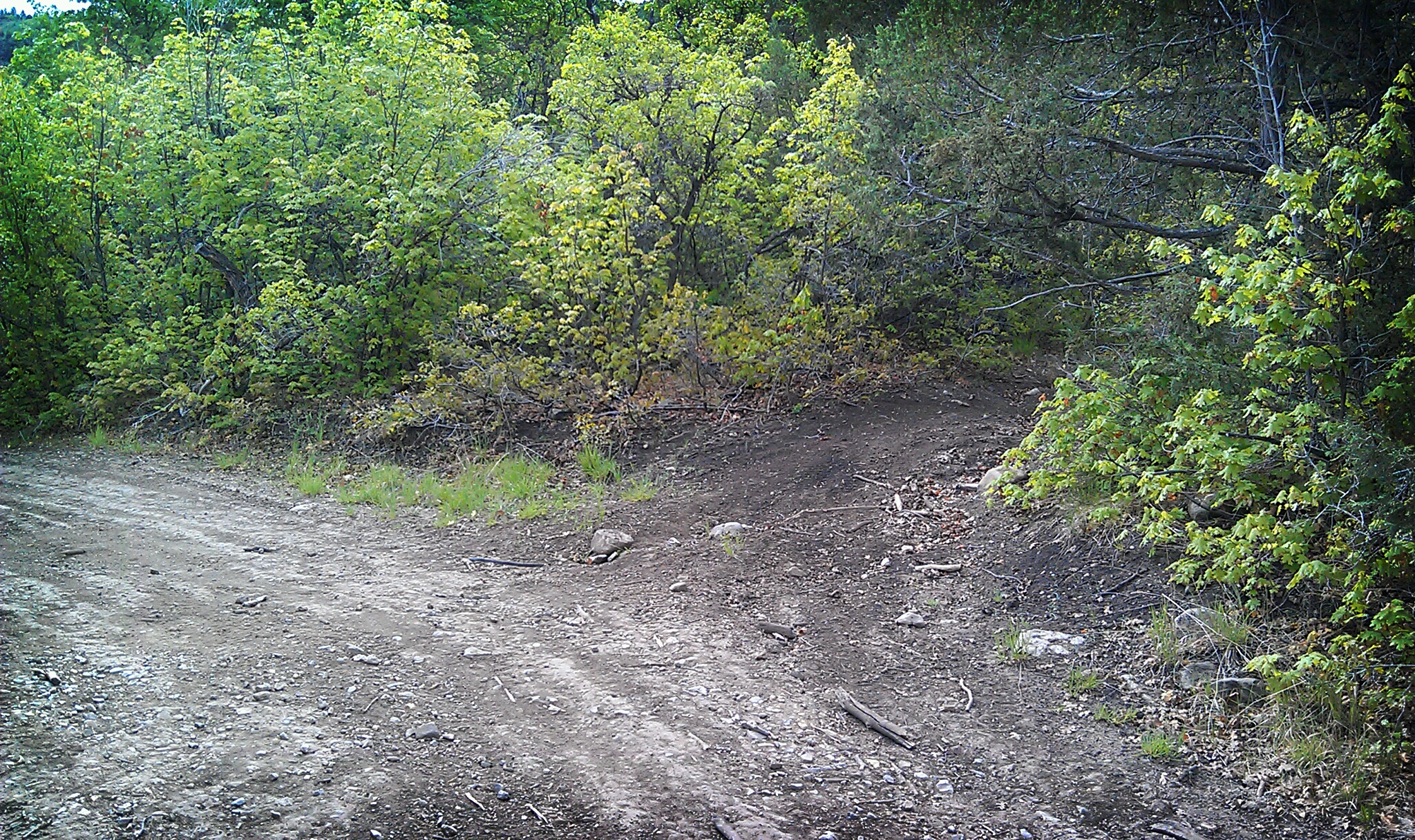
| "Backbone" Trail Head |
The difficulty of this trail may be a bit subjective. It is rated as difficult because of the exposed areas in the trail and the steepness of some of the climbs. The trail can be slick at times which will add to the difficulty as well. There are not too many obstacles however and many smooth winding single track trails through the trees. A GPS is very useful on this trail as there are many tees and turns, but most of the time the trail is obvious and dirt bike tracks can be seen in the route. Since this is used by Mountain Bikes as well, take care to not widen or tear up the trail as much as possible.
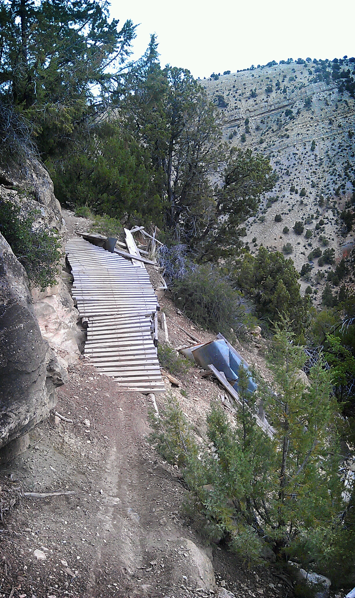
 |
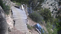
| Bridge Along Flume Trail |
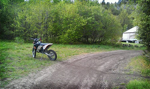 |
| Maple Syrup Trail Starts Here, Yurt In Background |
 |
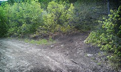
| End Of Camelot Trail, Continue Right on ATV trail |


Excellent video Tony. Had one of those "This Sucks" moments up American Fork Canyon yesterday. Lucky I had two other guys with to held pull the bike back up. This trail looks great, can you add to it for length or is that about it?
ReplyDeleteThanks! Dang, I almost had to call my brother, took all I had to drag it back onto the trail. There are some other good trails in the area..I'll be posting a couple more soon. As far as this loop though, ..you could take a right out jimmy's fork(39.318591,-111.496578)at the top of the loop instead of immediately towards the main canyon, there's some fun stuff out there..then come back and down the pioneer etc. not single track though. Arapeen trail system up on top is fun, and some fun stuff out in new canyon area(be posting this soon). Here's a link to some of the stuff out jimmy's fork/willow creek. http://www.bogord.com/2011/07/willow-creek-loop-trail.html I usually just ride all over when we go down. It's hard to put a good ride together on paper sometimes :)
DeleteAnother option may be after going down the flume or instead of..take the road out new canyon(SR39) from the main canyon road. There are a few good trails I'll be posting up in that area that drop down to black hill and/or go up to skyline..fun, lot's of options. Look for yellow markers on the maps in the future to link to other trails.
Deletetony, let's hook up for some riding. email me at duro.darin@gmail.com
ReplyDelete