Riding dirt bikes at "The Cinders", or Cinder Hills OHV and ATV area may be best described as riding at a ski resort for dirt bikes. The differences are that instead of snow you have volcanic cinders, instead of going down the runs, you go up them. I can't say that I love skiing like I love dirt biking, but I loved riding at Cinder Hills. Many say that it is like riding in sand,
 |
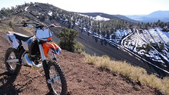
| Near Double Crater |
and although this is very true in the sense that you have to ride hard and keep your speed up to add stability to your bike, there are elements here that make riding here more than a trip to the dunes. There is a variety of terrain that can't be found at most dune areas. The trees scattered throughout and the way the cinders tend to form trails in the trees create the uphill ski run effect. Of course there are the big open areas and huge soft hill climbs here too if that's more your style. Beginners on dirt bikes would probably have a hard time adapting to the cinders. They are soft and if you don't keep your speed up and weight distribution right they can eat you up. Beginners on buggies and ATV's may have an easier time here as flotation is better and you don't have to worry about balance and speed as much. There are some easier sections however I found that are located towards the South of the area(see map below). Green markers and green shading on the map indicate the easier terrain. In the middle is some intermediate stuff, and the reds and North side are more advanced terrain. Click the camera icons to view pictures of the areas shown. More advanced riders can explore to the mountains of cinders and should be able to find something to their liking here easily.
- Distance Traveled: Open, freeride area. approx 13,500 acres
- Difficulty: Moderate to Difficult
- Best Time To Ride: Spring or Fall, sometimes winter depending on snow pack
- Elevation: Around 7,000 feet
- Type: Volcanic Cinders
- Location: 12 Miles Northeast of Flagstaff AZ (see map). Click for Directions to Cinder Hills AZ from your location, see the map below for trail route information
[Flags:Access To Area, Red Markers:Difficult, Green Markers:Easy, Camera Markers:Pictures]
Key GPS Points
- Main Access: 35.328527,-111.54538
- Main Staging Area: 35.32795, -111.52562
- Cinder Flats: (green teardrop on map, easier) 35.29668, -111.46611
- Hundred Dollar Hill Climb Area: 35.35266, -111.47754
- Double Crater: 35.345848,-111.45117
 |
| Cinder Flats Area, Easier |
When I visited Cinder Hills, the main access road had washed away. There are other ways to get in as shown by the flags on the map. The easiest for me was to the South of the main access on Sunset Blvd. It does not cost anything to ride here, but there is a fee area North along the road to Sunset Crater. A paddle tire here could prove useful, although there are a few areas where a paddle would hamper travel. My choice would be a very aggressive scoop shape knobby. Some of the very large loose climbs may require a paddle, but I got around most of the area fine with a regular knobby. Speed is key here. If you ride slow you fight the cinders too much and start to dig in. The cinders do tend to eat tires quickly, but I was actually pleased after the few days I rode here to see I had not destroyed my tire. I rode here in late November and was surprised at the lack of crowds and excellent riding conditions.
 |
| Some of the Intermediate Area. Cinders are moderately deep and soft, with some terrain change. |


No comments:
Post a Comment